
Lake Characteristics
- Length: 20.9 mi (33.6 km)
- Maximum width: 5.5 mi (8.8 km)
- Average depth: 22.3 ft (6.8 m)
- Amount of water (at 367 ft): 370 billion gallons
- Length of shoreline: 54.7 mi (88.0 km)
- Time for water to flow through: 235 days
- Prevailing winds: westerly to northwesterly
Watershed History
Oneida Lake is a remnant of Lake Iroquois that was impounded by a glacier approximately 12,000 years ago. The first major development occurred in the early 1800s. Industrial initiatives included the logging business, sand business, basket making, salt industry, summer resorts, and the glass industry.
Watershed Characteristics
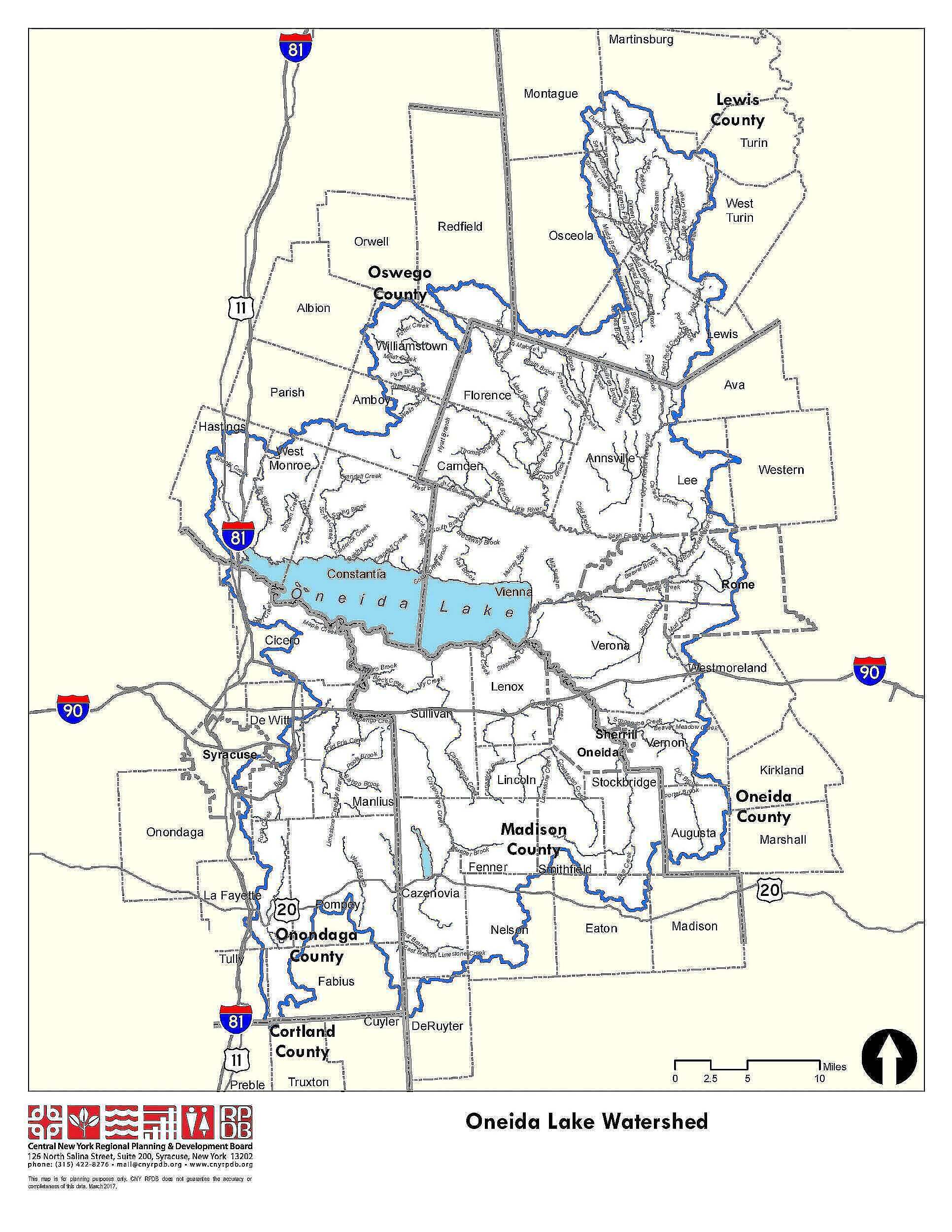
- The watershed includes portions of 69 municipalities and a total of 872,722 acres; surface water and groundwater from this area drains into Oneida Lake:
- 34% is in Oneida County
- 25% is in Madison County
- 16% is in Onondaga County
- 14% is in Oswego County
- 10% is in Lewis County
- <1% is in Cortland County
- Approximately 29% of the total land area in the watershed is classified as agricultural and is primarily located in Madison, Oneida, and Onondaga Counties
- The diverse land use, geology, and soil types influence water quality. Approximately 67% of the Lake surface water volume is from the region north of the lake. Most of sediment and nutrients originate from the southern region.
- There are 850 miles of trout streams in the Oneida Lake watershed, including 141 miles of stocked streams.
- The net economic value of Oneida Lake’s freshwater fishery was estimated in 1996 to be more than $9.4 million, ranking it first among New York’s inland waters.
Population Characteristics
- There are approximately 262,164 people living in the Oneida Lake watershed.
- Population trends (1970 to 2000) show an overall increase in the populations of Lewis, Madison and Oswego Counties, and a decline in Oneida and Onondaga Counties.
- Population densities ranged from 588 persons / sq. mile in Onondaga County to 21 persons / sq. mile in Lewis County in 2000.
- In 1900, 476 dwellings dotted the Oneida Lake shoreline; that number increased to 4298 by 1960. Shoreline populations continue to increase as dwellings along Oneida Lake are converted from seasonal camps to permanent residences.
- The average per capita personal income in the watershed ranged from $16,922 to $26,325 in 1998.
- Land use in the watershed is dominated by forest (47.5%) and agriculture (33.5%).
- Oneida Lake provides anglers with more fish per acre than any other lake in the northeastern United States.
- The net economic value of Oneida Lake’s freshwater fishery was estimated in 1996 to be more than $9.4 million, ranking it first among New York’s inland waters.
Municipalities in the Watershed
Cortland County (3)
- Town of Cuyler *
- Town of Preble *
- Town of Truxton *
Lewis County (6)
- Town of Lewis
- Town of Montague
- Town of Martinsburg
- Town of Osceola
- Town of Turin
- Town of West Turin
Madison County (17)
- City of Oneida
- Town of Cazenovia
- Town of DeRuyter
- Town of Eaton
- Town of Fenner
- Town of Lenox
- Town of Lincoln
- Town of Madison *
- Town of Nelson
- Town of Smithfield
- Town of Stockbridge
- Town of Sullivan
- Village of Canastota
- Village of Cazenovia
- Village of Chittenango
- Village of Munnsville
- Village of Wampsville
Oneida County (19)
- City of Rome (inner & outer dist)
- City of Sherrill
- Town of Annsville
- Town of Augusta
- Town of Ava
- Town of Camden
- Town of Florence
- Town of Kirkland *
- Town of Lee
- Town of Marshall *
- Town of Verona
- Town of Vernon
- Town of Vienna
- Town of Western *
- Town of Westmoreland
- Village of Camden
- Village of Oneida Castle
- Village of Sylvan Beach
- Village of Vernon
Onondaga County (13)
- City of Syracuse
- Town of Cicero
- Town of Dewitt
- Town of Fabius
- Town of Lafayette
- Town of Manlius
- Town of Onondaga
- Town of Pompey
- Town of Tully
- Village of East Syracuse
- Village of Fayetteville
- Village of Manlius
- Village of Minoa
Oswego County (11)
- Town of Amboy
- Town of Albion *
- Town of Constantia
- Town of Hastings
- Town of Orwell *
- Town of Parish
- Town of Redfield
- Town of West Monroe
- Town of Williamstown
- Village of Central Square
- Village of Cleveland
* Indicates municipalities that have less than one-half square mile of land located within the watershed boundary (from data prepared by the Syracuse-Onondaga County Planning Agency, April 2001)